Preamble:
The recent Trishuli disaster is more than a reconstruction challenge. It asks Nepal to rethink how we engineer infrastructure, assess investment risk, locate settlements, and even organize our university system around the realities of a fragile mountain environment. I reflect here on an idea I have long called “development federalism”—seeing Nepal’s river basins not as locations for isolated projects, but as interconnected ecological, economic, infrastructure, risk, and knowledge systems. Universities can become regional learning anchors within that geography. And because Himalayan risks do not stop at national borders, I end by suggesting a China–Nepal–India trilateral mechanism for glacier monitoring, scientific cooperation, and early warning across the Third Pole.
The View from the Watershed
The images of the recent Himalayan flood were difficult for me to watch. They brought back vivid memories from many decades ago when, as a young student volunteer, I spent nearly a year living and working in that part of Nepal.
We had trekked all the way to the Timure border and once spent a night in that small settlement nestled between two towering peaks. Timure is now reportedly gone. Syabrubesi, where three rivers meet, has been devastated. Betrawati, another town we used to visit, has been inundated. Watching the extraordinary height, volume, and speed of the water—and seeing familiar places transformed almost beyond recognition—was heartbreaking.
Those memories were very much on my mind when Al Jazeera English recently asked me to discuss the economic consequences of the disaster. I went into the interview expecting to talk primarily about the immediate economic consequences:
Reconstruction burden: Preliminary estimates place total losses and rebuilding needs between $4 billion and $5 billion—roughly one-tenth of Nepal’s GDP.
Energy shock: Structural damage along the Trishuli corridor reportedly affected roughly 360 MW of hydropower capacity, around 10–12 percent of the national total.
Trade bottleneck: Disruption at the Rasuwagadhi/Gyirong border crossing severed (40 km road damaged) an important land-trade connection with China.
Fiscal and growth pressure: The reconstruction burden arrives when Nepal is already confronting limited fiscal space and relatively weak economic growth.
The precise numbers will inevitably change as damage assessments improve. But the scale of the shock is already clear. The damage is not confined to physical structures. When a Himalayan corridor collapses, the consequences travel through electricity, trade, tourism, agriculture, local markets, public finances, private investment, and household livelihoods. The interview preparation itself estimated reconstruction costs of $4–5 billion and noted substantial damage to hydropower and transport infrastructure.
These are urgent questions. But as I prepared for the live conversation, another, more fundamental question kept intruding:
What exactly should Nepal rebuild?
If climate and ecological risks in the Himalayas are changing, rebuilding yesterday’s infrastructure in yesterday’s locations according to yesterday’s assumptions may simply reconstruct yesterday’s vulnerabilities.
Three words eventually organized my thoughts for the interview:
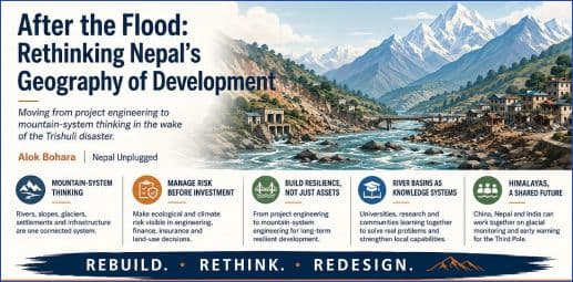
Rebuild. Rethink. Redesign.
Rebuild, because communities, roads, bridges, hydropower facilities, and local livelihoods must recover.
Rethink, because this disaster raises uncomfortable questions about some of the assumptions underlying Himalayan engineering, settlement planning, and capital investment.
Redesign, because Nepal must increasingly see its mountains and rivers not as isolated sites for separate projects, but as interconnected ecological and economic systems.
The disaster, in fact, exposes at least three areas requiring a rethink.
There is engineering risk: whether infrastructure designed and evaluated project by project adequately incorporates changing mountain-system dynamics.
There is investment risk: whether governments, banks, developers, and insurers are adequately recognizing ecological and cascading risks before committing capital.
And there is household location risk: whether families investing their lifetime savings in land and housing have enough information about floodplains (flood insurance?), unstable slopes, river migration, and other hazards before they build.
These may appear to be separate problems. But in the Himalayas they ultimately confront the same underlying system: the watershed.
From Project Engineering to Mountain-System Engineering
Nepal still needs hydropower. It needs roads, transmission lines, tourism infrastructure, towns, and housing. The lesson of the flood is not that development should retreat from the mountains. The question is how development should incorporate the mountains.
For decades, we have understandably evaluated infrastructure largely project by project. Is this hydropower plant technically feasible? Is this road economically justified? Is this piece of land suitable for construction? Can this hotel attract tourists?
But a Himalayan river does not recognize project boundaries.
The same watershed connects glaciers, rainfall, slopes, forests, sediment, hydropower facilities, bridges, roads, agricultural land, transmission infrastructure, tourism facilities, and downstream settlements. A disruption in one part of that system can cascade rapidly through others.
Nepal therefore needs to move from isolated project engineering toward mountain-system engineering.
And once we make that shift, engineering quickly becomes something larger than engineering. Ecological knowledge must inform engineering and investment, while experience—including failure—must feed back into research and better decisions.
Development in a fragile mountain environment has to become a learning system.
Making Risk Visible Before Investment
Consider something as ordinary—and as consequential—as a family building a house near a river.
For the family, that house may represent thirty years of savings. For a bank, it may become collateral for a mortgage. For a municipality, it is part of an expanding settlement. For an insurer, it represents a particular exposure (flood insurance). For an engineer, it is a structure designed according to particular standards.
Yet all these decisions ultimately depend upon the same ecological reality.
How high might the river rise? Could its course change? What is happening upstream? Is the adjoining slope stable? How is the watershed changing? What happens when extreme rainfall, landslides, sediment, and river flows interact?
The same questions apply at a much larger scale to hydropower plants, highways, bridges, hotels, transmission lines, and industrial facilities.
Risk therefore cannot remain something considered primarily by environmental specialists after major investment decisions have already been made. Ecological and climate risk must increasingly become an input into engineering, investment, bank lending, insurance, land-use planning, and household decisions.
Imagine gradually overlaying Nepal’s infrastructure and investment decisions with credible spatial ecological-risk information.
A bank considering a hydropower loan could evaluate watershed and cascading infrastructure risks. A municipality considering a housing development could see flood and slope exposure. A household buying land could understand the risks before committing its lifetime savings. Insurers could price risk more intelligently. Engineers could design accordingly.
Such a system would not eliminate Himalayan risk. Nothing can.
But it could make risk visible before investment rather than painfully visible afterward.
River Basins as Development Systems
This brings me back to an idea I have advocated periodically over the years: thinking about Nepal’s development through its major river-basin ecological corridors—the Karnali, Gandaki, Bagmati, and Koshi—as a form of development federalism.
The argument is not that Nepal should replace its political federal structure with river-basin governments. Provinces and municipalities serve important administrative and democratic functions.
But nature has drawn another map.
Water, sediment, biodiversity, glacial systems, landslides, agricultural ecosystems, and flood risks cross provincial and municipal boundaries without asking permission.
Economic systems increasingly intersect with those same corridors: hydropower, roads, transmission lines, agriculture, tourism, markets, towns, and settlements.
Nepal therefore needs to become better at overlaying its administrative geography with its ecological-development geography.
This is the essence of what I have called development federalism. Political federalism tells us who governs within administrative boundaries. Development federalism asks how economic activity, infrastructure, knowledge, environmental stewardship, and risk management can be coordinated across the functional geography through which they actually interact.
In a Himalayan country, the river basin provides one natural organizing geography for doing so.
A river basin can simultaneously be understood as an ecological system, an economic corridor, an infrastructure network, and a risk corridor.
But what if we also began treating the river basin as a knowledge system?
What Does a River Basin Need to Know?
Nepal has spent considerable effort expanding universities and higher education geographically. Yet locating a university or campus outside Kathmandu does not automatically create a regional knowledge ecosystem. Often, many end up opening their branches in the capital defying the very essence of developing the the regional knowledge base.
Perhaps we should turn the usual question around.
Instead of asking primarily what standard degree programs a regional university should offer, ask:
What does this particular ecological and economic region need to learn how to do?
A university embedded within a Himalayan river basin could become a knowledge anchor connecting hydrology, geology, civil engineering, agriculture, forestry, biodiversity, tourism, GIS, disaster science, energy systems, environmental economics, public health, and even insurance and risk finance.
The basin itself could become a laboratory.
Engineering failures would generate research questions. Flood events would improve risk models. Agricultural problems would enter laboratories and classrooms. Hydropower projects would generate engineering and ecological knowledge. Municipalities would bring urban planning problems to researchers. Students would encounter real problems generated by the region around them.
Knowledge would then flow back into engineering, investment, public policy, and community decisions. The river basin itself becomes a living laboratory where real problems generate research, learning, and better development.
Higher education could thereby become a regional learning anchor, building knowledge and specialized capabilities around the problems and opportunities of the basin.
Different river basins need not develop identical expertise. Nepal’s geography itself could encourage several specialized centers of knowledge and technical capability rather than continually drawing sophisticated expertise toward Kathmandu.
That would give development federalism another dimension: not merely decentralizing government, but gradually developing polycentric centers of knowledge, engineering, and problem-solving capacity around Nepal’s ecological and economic geography.
The Geography of Opportunity Is Also the Geography of Risk
There is a larger lesson here.
Nepal has traditionally viewed its rivers primarily through the enormous opportunities they offer: hydropower, irrigation, agriculture, tourism, transportation corridors, urban development, and potentially much greater regional economic integration.
Those opportunities remain.
But the Trishuli disaster has demonstrated painfully what Nepal’s geography has always been telling us:
The same rivers that constitute Nepal’s development opportunity also constitute its ecological risk.
The two cannot be separated.
A hydropower strategy is therefore partly a watershed strategy.
A road strategy is partly a landslide and settlement strategy.
A housing strategy is partly a flood-risk strategy.
A tourism strategy is partly an ecological-resilience strategy.
And a regional university strategy could become part of the knowledge infrastructure through which Nepal continually learns how these systems interact.
This is why the flood should lead us beyond the familiar call to “build back better.” The deeper challenge may be to build forward differently.
Beyond Nepal: A Himalayan Risk Commons
There is one more implication.
The mountain system does not stop at Nepal’s national borders any more than a river stops at a provincial boundary.
The greater Himalayan region contains tens of thousands of glaciers, including thousands associated with Nepal and its transboundary basins. Many are changing rapidly, and glacial lakes and other high-mountain hazards create risks that require increasingly careful monitoring. The exact counts vary with the geographic boundaries, definitions, and glacier inventories used, so the often-cited figures of roughly 24,000 Himalayan glaciers and around 2,000 in Nepal should be treated as approximate rather than definitive.
But the larger point does not depend upon the precise number.
The Himalayas and Tibetan Plateau constitute an enormous high-altitude store of snow and ice—the region often described as the Third Pole. Rivers originating in this system cross China, Nepal, India, and other countries before flowing through some of the most densely populated landscapes on Earth. Changes high in the mountains can therefore have consequences for water, agriculture, settlements, hydropower, infrastructure, and livelihoods far downstream.
That makes Himalayan risk more than a national problem.
China, Nepal, and India should consider establishing a trilateral Himalayan glacier and high-mountain risk monitoring mechanism.
The objective need not begin with a grand geopolitical agreement. It could begin with science.
Universities, glaciologists, hydrologists, remote-sensing specialists, meteorological agencies, disaster-management institutions, and mountain communities could strengthen cooperation around satellite observations, glacial-lake monitoring, hydrological information, early-warning systems, and shared scientific understanding of emerging high-mountain risks.
Nepal, situated between the two Himalayan giants, could even help provide the intellectual and institutional space for such cooperation (e.g., ICIMOD).
The Himalayas are a shared water tower.
They are also a shared risk system.
What happens upstream can profoundly affect communities downstream, while infrastructure and settlement decisions downstream determine how ecological shocks ultimately become human disasters. A mountain-system perspective therefore eventually requires us to think across municipal, provincial, and national boundaries.
Rebuild. Rethink. Redesign.
Reconstruction is the immediate and non-negotiable task. Families need shelter. Roads and bridges must reconnect communities. Power infrastructure must be restored. Local economies must recover.
But reconstruction also creates choices.
Nepal can replace individual concrete assets and restore yesterday’s economy alongside yesterday’s vulnerabilities.
Or it can use this tragedy to begin redesigning the broader system in which those assets live.
That means bringing engineers together with climate scientists; banks with risk analysts; universities with municipalities; hydropower developers with watershed specialists; households with better land-risk information (flood insurance); and infrastructure planners with the ecological systems their investments ultimately depend upon.
This does not require another grand national blueprint. It requires a different way of seeing Nepal’s geography.
The mountains, rivers, roads, power plants, farms, towns, universities, businesses, and households do not inhabit separate development worlds. They interact within the same living system.
And the lesson extends beyond Nepal. Watersheds cross municipalities, provinces, and national borders. Our institutions of engineering, investment, knowledge, and risk management increasingly need to learn to do the same.
If Nepal merely rebuilds what the water swept away, we risk reconstructing yesterday’s vulnerabilities.
But if reconstruction becomes an opportunity to rethink the relationship among ecology, engineering, investment, settlement, knowledge, and regional development, something more consequential could emerge from this tragedy: a development paradigm built not around imposing individual projects upon a fragile Himalayan landscape, but around learning how to develop with the mountain-river system itself.
Rebuild. Rethink. Redesign.
Dr. Alok K. Bohara, Emeritus Professor of Economics at the University of New Mexico, writes as an independent observer of Nepal’s democratic evolution through the lens of complexity and emergence science. His systems-policy essays on Nepal’s socio-economic and political landscape appear on Nepal Unplugged.