By: Galab Bahadur Dhungana--------------
The images from Nepal’s northern frontier are difficult to absorb. Settlements erased, bridges torn from their foundations, and families still waiting for news of the missing. As of August 29, officials had confirmed 675 deaths and nearly 2,500 people still missing in Nepal, with seven deaths confirmed in Tibet, and cautioned that both figures were still rising as search and rescue operations continued. Saving lives remains the urgent priority. But this disaster also carries a structural warning Nepal cannot afford to forget once the news cycle moves on.
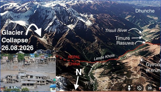
On August 26, current assessments indicate a massive high-altitude collapse of ice and rock entered the transboundary Lhende Khola on the Tibetan side of the border, though scientists are still reconstructing the exact chain of events. What followed was not a conventional monsoon overflow but a hyper-concentrated debris surge that tore down the Bhote Koshi and into the Trishuli, with river levels downstream reportedly rising by up to nine metres in thirty minutes. The flood flattened border infrastructure at Rasuwagadhi, destroyed the bazaars of Timure and Syabrubesi, and carried on into Nuwakot and Dhading, destroying 35 motorable bridges, 45 suspension bridges and around 40 kilometres of road along the way. A barrier lake formed upstream and partially breached on August 28, and a second, larger blockage has since been spotted still growing.
The energy toll has been just as severe. The Nepal Electricity Authority now counts fourteen hydropower projects along this single river corridor damaged or halted, nine of them operating plants and five still under construction, with roughly 750 MW of combined operating and under-construction capacity affected, including about 354 MW that had been feeding the grid. Some 933 hydropower workers remain unaccounted for at project sites alone, alongside Kailash-bound pilgrims who were caught in the same corridor.
To understand why this disaster hit so hard, it helps to look at the geography beneath it. For centuries the Himalayan range was never an impenetrable wall. Trade moved through roughly forty traditional passes, eventually consolidating into modern gateways like Kodari, Rasuwagadhi, Hilsa and Korala. Some of these routes crossed high mountain saddles, while others followed valleys and gorges shaped by glaciers and trans-Himalayan rivers such as the Arun, Karnali and Bhote Koshi. Caravans, pastoralists and pilgrims simply followed the water downhill, and in recent decades Nepal built its modern economy along these same gorges, with highways, border posts, tourism hubs, transmission towers and cascading hydropower plants replacing the old salt and wool caravans. It made commercial sense to exploit fast-flowing Himalayan rivers. But it created a dangerous paradox. The narrow geography that makes human movement and energy generation possible is the exact channel through which an upstream catastrophe propagates downstream, destroying everything in an unbroken chain.
Rasuwa exposes the illusion of diversified hydropower risk. Clustering dozens of plants along the same river system to share access roads and transmission lines makes economic sense in ordinary years, but it also means those plants share the same watershed, fragile slopes, flood pathways and glacial hazard corridors. When an upstream event strikes, generation, transmission hubs like the Trishuli-3B substation, and the access roads needed to reach them can all fail together. This is not an isolated weakness either. The Koshi basin in the east, with the Arun, Tamor and Dudh Koshi, the Gandaki system with the Marsyangdi and Budhi Gandaki, and the Karnali-Bheri basins in the west all carry the same pattern, heavy hydropower concentration sitting just downstream of steep, glaciated catchments.
These assets are also operating in a mountain environment that will not sit still. ICIMOD assessments show that glaciers across the Hindu Kush Himalaya are losing mass at roughly twice the rate recorded at the start of this century, having already lost about twelve percent of their area and nine percent of their estimated ice reserves between 1990 and 2020. Warming, glacier retreat and degrading permafrost are also altering the stability of high mountain slopes and increasing concern about rock and ice avalanches that may occur independently of glacial lakes. The physical assumptions behind infrastructure meant to last thirty to fifty years are shifting faster than the infrastructure itself.
None of this is an argument against hydropower, which remains the backbone of Nepal’s domestic power supply and its export earnings from India. It is an argument for planning the way the mountains actually behave, as connected systems rather than isolated project sites. Energy diversification must therefore mean not only more projects or more river basins, but diversification of geography, technology and transmission risk. Regulators need basin-scale risk audits rather than project-by-project environmental reviews, modeling how an avalanche or debris flow would travel and how many dams downstream could fail together, not just whether one dam site is sound. Energy security needs real technology diversification, with utility-scale solar and battery storage built out across the mid-hills and Terai, well away from river corridors, since a flash flood that can wipe out a string of hydropower plants cannot touch a dispersed solar array. The disaster is also a reminder that Himalayan environmental security is fundamentally a Nepal-China-India problem, not only a Nepal-China one, since glaciers, rivers and debris flows do not recognise political borders and these same waters continue on toward India downstream. Transboundary early warning matters too. These debris surges move faster than standard downstream flood gauges can register, which makes real-time seismic, satellite and hydrometric data sharing between Nepal, China and India essential for shared headwaters like the Lhende Khola. And the grid itself needs redundancy, with substations sited outside flood-prone valleys and transmission lines looped so that one corridor’s destruction does not paralyze the wider system.
Nature has delivered an unmistakable warning. The Himalayas will keep defining Nepal’s geography, its trade routes, its pilgrimage paths and, increasingly, its electricity supply. What is not fixed is whether Nepal’s energy planning catches up to the volatile mountain system it is actually built on, or waits for the next corridor to collapse before it does.